
Where Is Iguazu Falls? A Complete Guide to Its Exact Location
Iguazu Falls sits on the border between Argentina and Brazil, where the Iguazu River drops into a system of 275 cascades — just minutes from a third country, Paraguay. This guide covers the exact location, coordinates, and which side holds the best views.
Where Is Iguazu Falls Located?
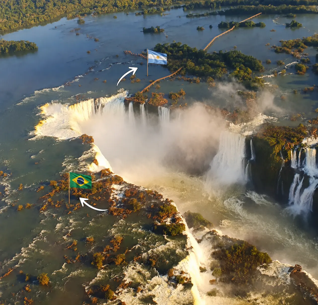
Iguazu Falls is located in South America, on the border between the Argentine province of Misiones and the Brazilian state of Paraná. The falls sit on the Iguazu River, close to the point where it meets the Paraná River — right at the tri-border area shared by Argentina, Brazil, and Paraguay.
The two closest cities are:
- Puerto Iguazú, Argentina — the main base for the Argentine side of the park
- Foz do Iguaçu, Brazil — the main base for the Brazilian side of the park
Both cities have their own international airports, so which one you fly into often depends on which side of the falls you plan to prioritize.
Iguazu Falls Coordinates and Exact Position
GPS Coordinates
For anyone plotting the falls on a map or GPS device, the widely cited coordinates for Iguazu Falls are approximately 25°41′S, 54°26′W. This places the falls roughly 1,300 km (800 miles) northeast of Buenos Aires and about 650 km (400 miles) west of São Paulo.
The Argentina–Brazil–Paraguay Triple Frontier
Iguazu Falls sits inside one of the most unusual borders in South America: the Triple Frontier (Triple Frontera / Tríplice Fronteira), where Argentina, Brazil, and Paraguay meet at the confluence of the Iguazu and Paraná rivers.
While the falls themselves are only in Argentina and Brazil, Paraguay’s Ciudad del Este is close enough that many travelers add it as a short stop — mostly for duty-free shopping, since it doesn’t have its own access point to the falls.
What Is Iguazu Falls? Quick Facts
Before going further into the geography, it helps to understand what exactly you’re looking at on a map.
- Number of individual waterfalls: around 275, depending on water levels
- Height: up to 82 meters (269 feet) at the tallest point
- Total width: roughly 2.7 km (1.7 miles) across the full system
- Average water flow: around 1,750 cubic meters per second
- Status: UNESCO World Heritage Site (inscribed as Iguazú National Park) and one of the New7Wonders of Nature
The most famous section is the Devil’s Throat (Garganta del Diablo in Spanish, Garganta do Diabo in Portuguese), a U-shaped chasm where the largest volume of water plunges down — and where the border between Argentina and Brazil technically runs.
Are the Iguazu Falls in Brazil or Argentina?
This is the question that trips up most first-time visitors, and the honest answer is: both — but not equally.

The Brazilian Side
The Brazilian side, accessed from Foz do Iguaçu in the state of Paraná, holds a smaller share of the falls but offers the best panoramic views. A single main walkway lets visitors see almost the entire curtain of waterfalls from a distance, making it the side most people visit if they only have a few hours.
The Argentine Side
The Argentine side, accessed from Puerto Iguazú in Misiones province, holds the majority of the falls and offers a far more immersive experience. An extensive network of trails and catwalks brings visitors right up to — and in some cases over — the edge of individual cascades, including a walkway that leads directly to the Devil’s Throat.
How Much of the Falls Is in Each Country
Roughly 80% of Iguazu Falls lies within Argentina, with the remaining 20% in Brazil. This is why travelers looking for an up-close, hands-on experience tend to favor the Argentine side, while those wanting the best photos and widest overview tend to favor the Brazilian side — and why many visitors choose to see both, spread across two separate days.
How Iguazu Falls Was Formed (Geology in Brief)
Iguazu Falls sits on the edge of the Paraná Plateau, a massive basaltic lava plateau that covers parts of southern Brazil, eastern Paraguay, and northern Argentina, formed by volcanic activity linked to the breakup of the ancient supercontinent Gondwana.
The plateau’s basalt rock is extremely hard and resists erosion, which is why it forms the steep drops the water falls over. Above that hard basalt sits a thinner layer of softer sedimentary rock, which the Iguazu River has worn away much faster over thousands of years — carving the horseshoe shape of the Devil’s Throat and the terraced, stepped look of the wider falls system.
How to Get to Iguazu Falls
Most travelers reach the falls by flying into either:
- Cataratas del Iguazú International Airport (IGR) in Puerto Iguazú, Argentina
- Foz do Iguaçu International Airport (IGU) in Foz do Iguaçu, Brazil
There are no direct international flights from outside South America to either airport, so most visitors connect through Buenos Aires, São Paulo, or Rio de Janeiro first. If you’d rather skip the logistics of coordinating border crossings and transport yourself, a private guided tour handles all of that for you.
For a full breakdown of routes, bus options, and border-crossing tips from each major city, see our complete guide: How to Get to Iguazu Falls.
Already planning where to base yourself? See our guide on where to stay near Iguazu Falls.
Frequently Asked Questions
It’s closer to Buenos Aires — about a 2-hour flight — than to Rio de Janeiro, which is roughly a 2.5-hour flight from São Paulo plus additional travel time.
Two countries have direct access to the falls themselves — Argentina and Brazil. A third, Paraguay, is part of the surrounding Triple Frontier but doesn’t have its own entrance to the park.
Yes. Iguazu Falls is significantly wider than Niagara Falls, spanning close to 2.7 km compared to Niagara’s roughly 1.2 km, and consists of hundreds of individual falls rather than three main drops.